


The California Department of Forestry and Fire Protection (Cal Fire) maps identify areas most vulnerable to wildfires over the next several decades based on vegetation, terrain, fire history and local weather patterns. The timing is particularly relevant following January’s destructive Eaton and Palisades fires, which devastated Altadena.
“We are living in a new reality of extremes. California’s resilience means we will keep updating our standards in the most fire-prone areas,” Gov. Gavin Newsom said in a statement.
The maps cover eight southern counties: Los Angeles, Orange, Riverside, San Bernardino, San Diego, Imperial, Mono and Inyo. They categorize wildfire vulnerability into moderate, high and very high risk zones, with the updated designations expected to more than double the land area subject to stricter building codes.
Properties designated in high and very high fire zones face more stringent regulations, including requirements for fire-resistant roofs, tempered windows and ember-resistant vents. Residents must also maintain “defensible space” by clearing flammable brush within 100 feet of structures, with the greatest degree of vegetation control occurring within 30 feet of a home or building.
Statewide, the updated maps expand high and very high risk zones to 1.4 million acres, up from approximately 800,000 acres in previous versions. New regulations will also require property owners in very high risk zones to maintain “ember-free zones” within five feet of structures, prohibiting wooden gates, plants and bark mulch in that perimeter.
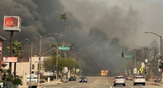
The Eaton Fire, which began near Altadena Drive and Midwick Drive in January, burned about 14,000 acres, destroyed over 9,400 structures and resulted in at least 17 fatalities, making it the second most destructive fire in California’s history.
Areas affected by recent wildfires, including Altadena, are likely to see increased hazard classifications in the new maps.
Local fire agencies conduct tens of thousands of brush inspections annually. The Los Angeles County Fire Department performs more than 129,000 inspections each spring, while the Orange County Fire Authority conducts over 85,000 after rainy seasons. Homes in L.A. County not in compliance get 30 days to make improvements, then must be reinspected. Homeowners failing compliance could face fines up to $500.
The maps don’t take into account efforts by homeowners or communities to minimize danger by clearing brush or hardening homes, so they don’t give a full picture of an area’s actual wildfire risk, according to Cal Fire.
Insurance companies typically use their own risk assessment data rather than these maps, so the new designations are unlikely to directly affect insurance rates, according to Cal Fire. However, they will impact real estate transactions, as sellers must disclose to buyers when properties are located in high and very high fire zones. They also must present documentation showing that an inspection was done within six months and that the property complies with defensible space requirements.
Local agencies have 120 days to adopt the maps by ordinance, ensuring alignment with state recommendations for fire prevention strategies and building codes.
 Get our daily Pasadena newspaper in your email box. Free.
Get all the latest Pasadena news, more than 10 fresh stories daily, 7 days a week at 7 a.m.


