


 0 comments

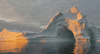
Scientists at NASA’s Jet Propulsion Laboratory in Pasadena, working with a team of international researchers, have used satellite data to determine Greenland’s ice sheet melted in 2019 at the fastest rate ever recorded, according to JPL.
The discovery was made not by observing the massive-but-shrinking ice sheet visually, but by mapping its gravitational pull using two satellites built and managed by JPL, the laboratory said in a written statement.
Following a “moderate” rate of ice melt over the previous two years, Greenland lost more ice in 2019 than it has since at least 1948, according to JPL.
“The large loss — 532 billion tons — is a stark reversal of the more moderate rate of melt seen in the previous two years. And it exceeds Greenland’s previous record of 464 billion tons, set in 2012,” the statement said.
“The record melt will likely raise average global sea level by 1.5 millimeters,” it continued. “Using a hypothetical comparison, all the water combined would cover the entire state of California in more than 4 feet of water.”
The data was published Thursday in the journal Communications Earth & Environment. It was obtained by using JPL’s Gravity Recovery and Climate Experiment, or GRACE, twin satellites, which operated from 2002 to 2017, and the GRACE Follow-On satellites, which have continued the mission since 2018. The information was then combined with data from computer models simulating snowfall and ice-sheet melting on Greenland.
JPL researcher and study co-author Alex Gardner said he was surprised by what the satellite data showed.
“What I found interesting is such a high variability in the rate of loss for the Greenland Ice Sheet,” he said. “The years 2017 and 2018 were relatively mild after a decade of record losses, then 2019 came back to set a new record.”
The satellites orbit in pairs and work in tandem to provide a gravitational map of te surface below, researchers explained.
“As one satellite passed over a gravitational ‘bump’ on Earth’s surface, it would speed up just a bit, changing the distance between it and its twin,” according to the JPL statement. “Precise measurements of these changes would yield the ‘weight,’ or mass, of the object below.”
Fellow researchers in Germany have deduced that the ice loss is due to climate-related changes in weather patterns, and noted that the five biggest years for ice melt have all taken place within the past decade.
“More and more often, we have stable [atmospheric] high-pressure systems over the ice sheet, which favor the influx of warmer air from the midlatitudes, one of the conditions promoting melt,” according to study leader Ingo Sasgen of the Alfred Wegener Institute in Bremerhaven, Germany. Scientists reported a similar pattern during the previous record ice melt year of 2012.
The GRACE missions are not the only ones currently gathering data on the effects of the atmosphere on Arctic ice melt.
Another study called NASA’s Oceans Melting Greenland, or OMG, uses an airplane to map changes along Greenland’s shore to help improve understanding of climate processes, according to JPL.
“When you look at the record as a whole, you start to see the long-term trend becoming more clear,” Gardner said.
 Get our daily Pasadena newspaper in your email box. Free.
Get all the latest Pasadena news, more than 10 fresh stories daily, 7 days a week at 7 a.m.


