




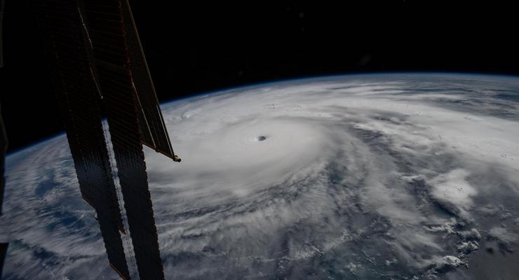
Two ocean-monitoring satellites carrying instruments contributed by NASA’s Jet Propulsion Laboratory in Pasadena are measuring sea levels during a strengthening El Niño, and the laboratory says the data will help produce more accurate hurricane predictions.
The data is arriving during what oceanographers expect to be a historic El Niño, JPL said.
The National Oceanic and Atmospheric Administration’s Climate Prediction Center said Sept. 8 that El Niño is strengthening and put the chance of a very strong event during the Northern Hemisphere fall and winter of 2026-27 at greater than 90%, with an El Niño Advisory in effect.
The satellites, Sentinel-6 Michael Freilich and Sentinel-6B, make up the Copernicus Sentinel-6/Jason-CS mission, the latest in a series of ocean-observing radar altimetry missions that have monitored Earth’s changing seas continuously since the early 1990s, JPL said in a news release Wednesday, Sept. 9.
Sentinel-6B launched last November to improve hurricane forecasts, help protect infrastructure and benefit commercial industries including shipping, and now flies 30 seconds behind its predecessor, according to the Sept. 9 release.
“This El Niño was a late-bloomer,” said Josh Willis, Sentinel-6B’s project scientist at JPL. “It didn’t kick off until the middle of the year and is just now reaching a strength similar to what we’ve seen in the satellite record during significant El Niños in 1997 and 2015. We expect it to be big, and it’s already having big impacts.”
El Niño redistributes heat in the ocean, and that shift moves hurricane activity from the Atlantic to the Pacific, JPL said.
Sentinel-6B began delivering low-latency data to scientists on July 15 that can be used in weather predictions. That data will take some time to work its way into the research models meteorologists and climate scientists rely on, the laboratory said.
Each Sentinel-6 satellite measures ocean height, wave size and marine wind speed with a radar altimeter that bounces thousands of radar pulses a second off the crests and troughs of waves. Because warm water expands, ocean height offers insight into how much heat the ocean holds, which in turn helps forecast how fast a hurricane will grow. Each satellite also carries a Global Navigation Satellite System – Radio Occultation instrument, which measures atmospheric humidity, pressure and temperature, according to JPL.
A tropical storm can take a week or more to become a hurricane and reach a coastline, but a hurricane can intensify rapidly in the 48 hours before landfall.
“Hurricanes have been known to speed up quickly at the last moment, so the window in which to decide what to do is short,” said Deirdre Byrne, an oceanographer and altimetry expert at the National Oceanic and Atmospheric Administration. “The goal is to forecast how much and how rapidly intensification will happen so that officials can make the right calls.”
Byrne oversees the National Oceanic and Atmospheric Administration’s Satellite Ocean Heat Content Suite, an operational product running since 2012. It measures ocean temperature from the sea surface down to the depth of the 26-degree-Celsius isotherm and is used to improve hurricane intensity forecasts and increase lead time on warnings, the agency said. Byrne plans to begin incorporating Sentinel-6 ocean-height data into the algorithm by the end of the year.
Data from the Sentinel-6 missions feeds hurricane tracking algorithms used by federal and state agencies, and those predictions can activate disaster response ranging from sandbag placement to National Guard activation. They can also lead to evacuation orders.
JPL, a division of Caltech in Pasadena, contributed three science instruments for each Sentinel-6 satellite: the Advanced Microwave Radiometer, the Global Navigation Satellite System – Radio Occultation instrument and the Laser Retroreflector Array. The mission was jointly developed by NASA, the National Oceanic and Atmospheric Administration, the European Space Agency and the European Organisation for the Exploitation of Meteorological Satellites, with funding support from the European Commission.
Sentinel-6B is scheduled to take over from Sentinel-6 Michael Freilich as the reference satellite for global sea level measurements later this year.
“The key is consistency, measuring the same way, every time,” said Severine Fournier, Sentinel-6B deputy project scientist at JPL. “That’s what lets us predict hurricanes, and, in turn, protect coastal communities and infrastructure.”
 Get our daily Pasadena newspaper in your email box. Free.
Get all the latest Pasadena news, more than 10 fresh stories daily, 7 days a week at 7 a.m.