



A heat wave will intensify across Pasadena beginning Tuesday, with temperatures climbing into the mid-90s and peaking near 98 degrees Wednesday, forecasters said. The National Weather Service warns of moderate to major heat impacts through Thursday as humidity compounds the discomfort.
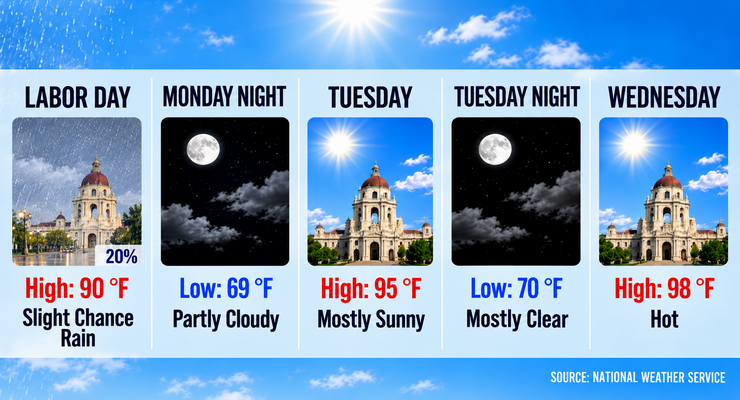
Pasadena will see mostly sunny skies today with a high near 90. Winds will shift from north to south-southwest at 5 to 10 mph. Tonight, partly cloudy skies and a 20 percent chance of rain are expected with a low around 69.
Tuesday’s high will reach 95, with heat index values as high as 106. Winds will remain light, offering little relief. Wednesday will be hotter, with highs near 98 under clear skies. Overnight lows will stay around 70, keeping evenings warm.
Forecasters expect highs in the 90s through midweek before easing slightly Friday into the low 90s. Weekend temperatures will settle in the upper 80s.
A 20 percent chance of showers lingers Monday, with isolated thunderstorms possible in northeast Los Angeles County. Sporadic showers may continue into Tuesday, though rainfall is expected to be light and fast-moving.
Winds will remain generally calm, shifting between north and southwest at 5 to 10 mph. Offshore flow midweek may delay sea breezes, allowing heat to build closer to the coast.
Saturday will be sunny with a high near 87. Sunday will remain clear with highs around 88, offering some relief after the midweek heat wave.
Pasadena residents are advised to stay hydrated, limit outdoor activity during peak afternoon hours, and check on vulnerable neighbors as heat persists.
The National Weather Service cautions of hazardous surf conditions at area beaches through Tuesday due to a strong southerly swell. Heat advisories are likely to be issued for the region by midweek.
Forecasters expect gradual cooling by Friday as the ridge of high pressure weakens. Next week’s outlook suggests highs in the upper 80s to low 90s with continued sunny skies.
Pasadena faces a short but intense heat wave beginning Tuesday, with highs near 98 and muggy conditions persisting through Thursday. Relief arrives by the weekend.
Here is the Pasadena forecast from the National Weather Service as of 3:26 a.m. Monday:
Labor Day: A 20 percent chance of rain. Mostly sunny, with a high near 90. North wind 5 to 10 mph becoming south southwest in the morning.
Monday Night: Partly cloudy, with a low around 69. West southwest wind around 5 mph becoming northeast in the evening.
Tuesday: Mostly sunny, with a high near 95. Heat index values as high as 106. Calm wind becoming southwest around 5 mph in the afternoon.
Tuesday Night: Mostly clear, with a low around 70. West southwest wind around 5 mph becoming calm.
Wednesday: Sunny and hot, with a high near 98.
Wednesday Night: Mostly clear, with a low around 70.
Thursday: Sunny, with a high near 95.
Thursday Night: Clear, with a low around 68.
Friday: Sunny, with a high near 91.
Friday Night: Clear, with a low around 64.
Saturday: Sunny, with a high near 87.
Saturday Night: Clear, with a low around 62.
Sunday: Sunny, with a high near 88.
 Get our daily Pasadena newspaper in your email box. Free.
Get all the latest Pasadena news, more than 10 fresh stories daily, 7 days a week at 7 a.m.