


A cool, cloudy stretch will continue in Pasadena through Saturday before a significant warming trend begins early next week, forecasters said Thursday.
The National Weather Service in Los Angeles/Oxnard reported highs near 77 degrees Today and Friday, with morning drizzle and patchy fog before gradual clearing. Temperatures will remain below normal through the weekend.
Today’s conditions included cloudy skies that became mostly sunny by afternoon, with south-southwest winds between 5 and 10 mph. Overnight lows dropped to about 53 degrees.

Forecasters said the marine layer will persist into Friday and Saturday, keeping highs near 77 degrees and lows in the low to mid-50s. Winds will remain light, generally from the south.
Temperatures will begin climbing Sunday, reaching 79 degrees under sunny skies. By Monday, highs are expected to reach 85 degrees, with continued warming through midweek.
No measurable rainfall is forecast, though drizzle may occur during morning hours Thursday and Friday.
Wind conditions in Pasadena will stay mild, with breezes around 5 to 10 mph. Stronger gusts are expected in interior valleys and foothills outside the city.
The weekend outlook shows Saturday holding steady at 77 degrees, while Sunday warms slightly. Nights will remain cool, with lows in the mid-50s to upper 50s.
Forecasters noted that Pasadena residents should prepare for hotter afternoons beginning Monday, with highs reaching the upper 80s to near 90 degrees by Wednesday.
The extended forecast calls for continued warming into next week, with highs in the upper 80s and lower 90s by midweek. Morning clouds will diminish, giving way to sunnier skies.
In summary, Pasadena will remain cool and cloudy through Saturday before summer heat builds early next week, bringing highs near 90 degrees by Wednesday.
Here is the Pasadena forecast from the National Weather Service as of 2:35 a.m. Thursday:
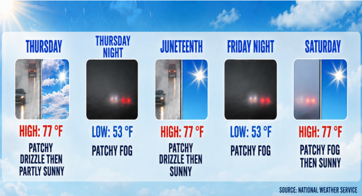
Thursday: Patchy drizzle before 11:00 a.m. Cloudy, then gradually becoming mostly sunny, with a high near 77. South southwest wind 5 to 10 mph.
Thursday Night: Patchy fog after 11:00 p.m. Otherwise, increasing clouds, with a low around 53. South southwest wind 5 to 10 mph becoming light south in the evening.
Juneteenth: Patchy drizzle before 11:00 a.m. Cloudy through mid morning, then gradual clearing, with a high near 77. Light south wind becoming south southwest 5 to 10 mph in the afternoon.
Friday Night: Patchy fog after 11:00 p.m. Otherwise, mostly cloudy, with a low around 53. South southwest wind 5 to 10 mph becoming light south southeast in the evening.
Saturday: Patchy fog before 11:00 a.m. Otherwise, mostly sunny, with a high near 77.
Saturday Night: Mostly clear, with a low around 54.
Sunday: Sunny, with a high near 79.
Sunday Night: Mostly clear, with a low around 57.
Monday: Sunny, with a high near 85.
Monday Night: Mostly clear, with a low around 60.
Tuesday: Sunny, with a high near 88.
Tuesday Night: Mostly clear, with a low around 63.
Wednesday: Sunny, with a high near 90.
 Get our daily Pasadena newspaper in your email box. Free.
Get all the latest Pasadena news, more than 10 fresh stories daily, 7 days a week at 7 a.m.