










Pasadena residents can expect a stretch of unseasonably warm weather through the weekend as a Santa Ana wind pattern pushes temperatures steadily higher, with highs forecast to approach 90 degrees by Friday, according to the National Weather Service.
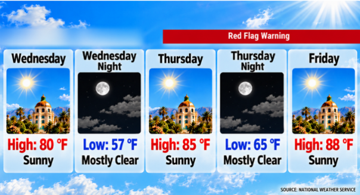
Forecasters said temperatures will rise from about 80 degrees Wednesday to 85 degrees Thursday before peaking near 88 degrees Friday. The warming trend is being driven by strengthening offshore winds associated with a Santa Ana event expected to reach its greatest intensity Friday.
Wednesday will remain pleasant, with sunny skies and a high near 80 degrees. Light north-northeast winds this morning will shift west during the afternoon. Overnight temperatures are expected to drop to around 57 degrees under mostly clear skies.
Warmer conditions arrive Thursday, when Pasadena is forecast to reach about 85 degrees. Northeast winds of 5 to 10 mph are expected, with gusts reaching 15 mph. Thursday night will remain mild, with a low near 65 degrees.
Friday is expected to be the hottest day of the forecast period. Sunny skies will continue as temperatures climb to around 88 degrees. Northeast winds of 10 to 15 mph are forecast, with gusts as high as 20 mph.
The National Weather Service said the Santa Ana wind event will produce very dry conditions across Southern California. While the strongest winds are expected in mountain and foothill areas, Pasadena will also experience the warm, dry air associated with the offshore flow.
Temperatures will remain elevated through the weekend. Highs are forecast to reach about 86 degrees Saturday and remain near 86 degrees Sunday under sunny skies. Overnight lows will stay in the low- to mid-60s.
No rain is forecast in Pasadena through Monday. Dry conditions are expected to persist through the weekend and into the start of next week.
A cooling trend is expected to begin Sunday and continue into Tuesday as offshore flow weakens and a trough approaches California. High temperatures are forecast to fall to about 83 degrees Monday and 74 degrees Tuesday.
Tuesday also brings Pasadena’s first chance of precipitation in the forecast period. The National Weather Service predicts a slight chance of showers as a cold upper-level system moves through the state. Forecasters said the system will likely be dry but could generate limited precipitation if sufficient moisture develops.
Here is the Pasadena forecast from the National Weather Service as of 2:37 a.m. Wednesday:
Today: Sunny, with a high near 80. North northeast wind around 5 mph becoming west in the afternoon.
Tonight: Mostly clear, with a low around 57. West wind 5 to 10 mph becoming north northeast in the evening.
Thursday: Sunny, with a high near 85. Northeast wind 5 to 10 mph, with gusts as high as 15 mph.
Thursday Night: Mostly clear, with a low around 65. Northeast wind 10 to 15 mph, with gusts as high as 20 mph.
Friday: Sunny, with a high near 88. Northeast wind 10 to 15 mph, with gusts as high as 20 mph.
Friday Night: Mostly clear, with a low around 64.
Saturday: Sunny, with a high near 86.
Saturday Night: Clear, with a low around 63.
Sunday: Sunny, with a high near 86.
Sunday Night: Clear, with a low around 62.
Monday: Sunny, with a high near 83.
Monday Night: Mostly clear, with a low around 57.
Tuesday: A slight chance of showers. Mostly sunny, with a high near 74.
 Get our daily Pasadena newspaper in your email box. Free.
Get all the latest Pasadena news, more than 10 fresh stories daily, 7 days a week at 7 a.m.