


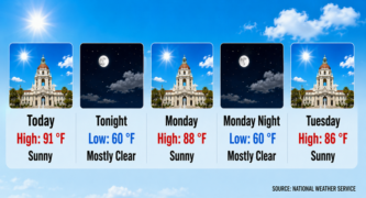

The extreme heat that gripped Pasadena and the San Gabriel Valley for the past week has broken, and the National Weather Service forecasts steadily cooler days into Monday before humidity and a chance of thunderstorms arrive Tuesday.
The last heat advisory covering the Pasadena area expired at 8 p.m. Saturday, and no heat watches, warnings or advisories were in effect for the city Sunday morning.
The shift ends a stretch in which forecasters posted back-to-back extreme heat warnings and advisories and the city kept a cooling center open six days last week at Robinson Park Recreation Center, according to a City of Pasadena news release.
“Cooler conditions will occur today and Monday,” the weather service wrote in its 2:50 a.m. forecast discussion Sunday. Falling upper-level heights and increasing onshore flow will bring 3 to 6 degrees of cooling each day, forecasters wrote, with high temperatures by Monday running 4 to 8 degrees below normal and valley highs only in the mid-80s to lower 90s.
The Pasadena point forecast calls for a sunny high near 92 degrees Sunday, 87 on Monday and 85 on Tuesday. Pasadena’s average high in September is 87 degrees, according to the city’s published climate averages.
The break may not last.
“More warm, tropical moisture could return,” the weather service wrote.
Marine layer clouds are expected to gradually redevelop and increase in coverage from Sunday into early this coming week, and forecasters project a degree or two of warming each day from Wednesday through Saturday.
But even with that warming, most of the region is forecast to stay below normal, with the San Gabriel Valley among the exceptions.
Beyond that, the picture is less settled. Forecasters wrote that more subtropical moisture is possible September 7 through 9, but noted a fair amount of disagreement among forecasting models.
 Get our daily Pasadena newspaper in your email box. Free.
Get all the latest Pasadena news, more than 10 fresh stories daily, 7 days a week at 7 a.m.