


City staff are recommending the commission forward the plan to the City Council for approval, along with an addendum to the city’s 2015 General Plan Environmental Impact Report, concluding that the proposal would not result in new significant environmental impacts beyond those already analyzed.
If recommended by the Planning Commission and approved by the City Council, the updated specific plan would serve as a long-term framework guiding land use, design standards and public improvements in the corridor, replacing the nearly two-decade-old plan currently in place.
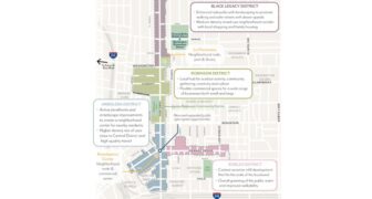
The proposed plan would replace the existing 2002 Fair Oaks Orange Grove Specific Plan and covers an area generally along Fair Oaks Avenue between Montana and Maple streets and along Orange Grove Boulevard between Lincoln and Oakland avenues.
The update builds on the city’s General Plan and incorporates elements from community-driven efforts such as the La Pintoresca Vision Plan and the North Fair Oaks Vision Plan, which prioritize affordable housing, economic opportunity and protections against displacement.
The plan envisions transforming the corridor into a series of pedestrian-oriented, mixed-use districts where residents can live, work and shop, while strengthening connections to surrounding neighborhoods and the Central District.
A key feature of the proposal is the division of the area into four subdistricts reflecting community history and identity: the Black Legacy District, Robinson District, Robles District and Arboleda District.
The Black Legacy District designation was introduced in response to community feedback to recognize the area’s historical significance to Pasadena’s Black community.
The plan also seeks to address longstanding inequities in the area, which historically experienced redlining, displacement tied to freeway construction and redevelopment policies, and limited access to resources.
Among the proposed changes are increases in allowable residential density along key corridors. Density along Fair Oaks Avenue north of Washington Boulevard would increase to 48 dwelling units per acre, while some locations could allow up to 64 units per acre to align with existing development patterns.
Building height limits would also increase in certain areas, with heights of up to 51 feet permitted in parts of the plan area, allowing for four-story mixed-use buildings.
The proposal calls for improvements to the public realm, including wider sidewalks ranging from 10 to 15 feet, enhanced streetscapes, expanded tree planting and improved pedestrian and bicycle infrastructure.
In addition, larger developments would be required to include publicly accessible open space such as plazas or pocket parks, aimed at increasing opportunities for community gathering and recreation.
 Get our daily Pasadena newspaper in your email box. Free.
Get all the latest Pasadena news, more than 10 fresh stories daily, 7 days a week at 7 a.m.


