









Pasadena is expected to experience a dramatic warming trend this week as a developing Santa Ana wind pattern steadily boosts temperatures from the low 70s Tuesday to the upper 80s by the weekend, according to the National Weather Service.
Forecasters said sunny and dry conditions will persist across Pasadena through at least Monday, with temperatures climbing each day as northeast winds strengthen later in the week.
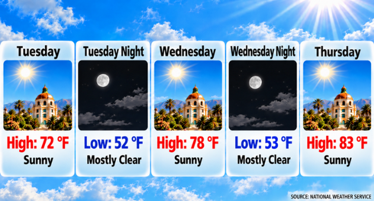
Tuesday will be sunny with a high near 72 degrees. Winds will remain light, becoming west-southwest around 5 mph during the afternoon. Overnight temperatures will fall to about 52 degrees under mostly clear skies.
The warming trend begins Wednesday, when temperatures are forecast to reach 78 degrees under sunny skies. Highs are expected to rise to 83 degrees Thursday, 86 degrees Friday and 88 degrees Saturday before easing slightly to 87 degrees Sunday and 84 degrees Monday.
The National Weather Service said a low-pressure system moving through the Great Basin is helping establish a Santa Ana weather pattern across Southern California. High pressure building over the Great Basin will drive increasingly warmer and drier air into lower elevations through the end of the week.
Pasadena residents can expect daytime temperatures to rise by more than 15 degrees between Tuesday and Saturday. Overnight lows also will increase, from 52 degrees Tuesday night to the low-to-mid 60s by the weekend.
Northeast winds will become more noticeable Thursday as the Santa Ana pattern develops. Thursday’s forecast calls for northeast winds of 5 to 10 mph with gusts up to 15 mph. While the strongest winds are expected in mountain and wind-prone areas of Los Angeles County, occasional breezy conditions could reach Pasadena, particularly during morning hours.
No rain is forecast for Pasadena through the weekend or into the start of next week. Forecasts call for continued sunny days and mostly clear nights.
The weekend is expected to bring the warmest conditions of the forecast period. Saturday’s high is forecast near 88 degrees, followed by 87 degrees Sunday. Nights will remain mild, with lows in the lower 60s.
Forecasters said temperatures should remain above normal through Sunday before gradually cooling next week. The National Weather Service is monitoring the possibility of a colder upper-level system arriving during the middle of next week, although any potential precipitation remains uncertain.
Here is the Pasadena forecast from the National Weather Service as of 3:35 a.m. Tuesday:
Today: Sunny, with a high near 72. Calm wind becoming west southwest around 5 mph in the afternoon.
Tonight: Mostly clear, with a low around 52. Calm wind becoming north northeast around 5 mph after midnight.
Wednesday: Sunny, with a high near 78. North northeast wind around 5 mph becoming west in the afternoon.
Wednesday Night: Mostly clear, with a low around 55. West wind 5 to 10 mph becoming north northeast in the evening.
Thursday: Sunny, with a high near 83. Northeast wind 5 to 10 mph, with gusts as high as 15 mph.
Thursday Night: Mostly clear, with a low around 63.
Friday: Sunny, with a high near 86.
Friday Night: Clear, with a low around 65.
Saturday: Sunny, with a high near 88.
Saturday Night: Clear, with a low around 63.
Sunday: Sunny, with a high near 87.
Sunday Night: Clear, with a low around 62.
Monday: Sunny, with a high near 84.
 Get our daily Pasadena newspaper in your email box. Free.
Get all the latest Pasadena news, more than 10 fresh stories daily, 7 days a week at 7 a.m.