








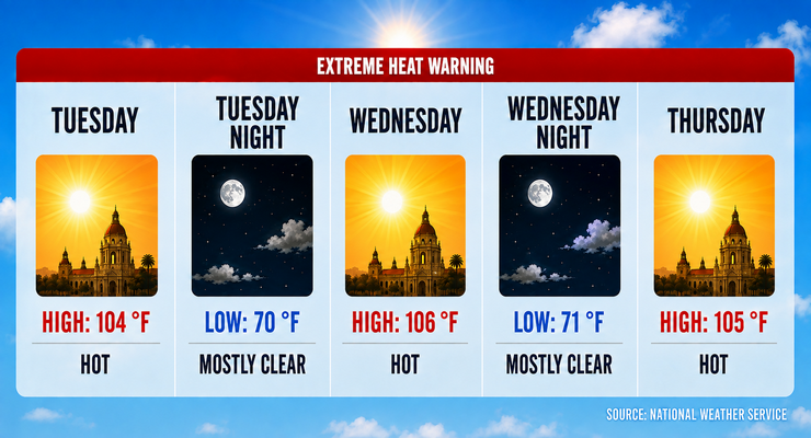
Today and over the next two days, Pasadena will bake during the peak of a heat wave which is expected to see temperatures climbing as high as 106 degrees, forecasters said Tuesday.
The National Weather Service in Oxnard reported that excessive heat warnings remain in effect through Thursday, citing elevated risks of heat illness.
Today’s forecast calls for mostly sunny skies and a high near 104 degrees. Heat index values could reach 110. Winds will stay light, shifting to a southwest breeze around 5 mph in the afternoon.
Forecasters said Wednesday will be the hottest day, with highs near 106 degrees. Thursday will remain oppressive, reaching 105 degrees. Overnight lows will stay elevated, between 70 and 73 degrees, offering little relief.
Temperatures will trend downward beginning Friday, with highs near 104. By Saturday, Pasadena will see a high around 98 degrees, dropping further to 93 on Sunday and 90 on Monday. Overnight lows will fall into the mid-60s, restoring more comfortable conditions.
No precipitation is forecast during the period. Winds will remain calm to light, generally from the southwest at 5 mph, providing minimal cooling.
The weekend outlook shows a marked improvement. Saturday and Sunday will be sunny but cooler, with highs in the low to mid-90s. Monday will continue the cooling trend, with highs near 90 degrees.
Local officials warn that the prolonged heat poses risks for vulnerable populations, particularly those without air conditioning. Residents are urged to limit outdoor activity, stay hydrated, and use cooling centers.
Extreme Heat Warnings and Advisories remain in place across the Los Angeles region, including Pasadena. The National Weather Service emphasized that heat illness is a serious risk until temperatures ease.
Looking ahead, forecasters expect continued cooling into next week, with highs settling into the upper 80s to low 90s signaling a return to more typical late-summer conditions.
Here is the Pasadena forecast from the National Weather Service as of 2:28 a.m. Tuesday:
Today: Mostly sunny and hot, with a high near 104. Heat index values as high as 110. Calm wind becoming southwest around 5 mph in the afternoon.
Tonight: Mostly clear, with a low around 70. Southwest wind around 5 mph becoming calm in the evening.
Wednesday: Sunny and hot, with a high near 106. Heat index values as high as 110. Calm wind becoming southwest around 5 mph in the afternoon.
Wednesday Night: Mostly clear, with a low around 71. Southwest wind around 5 mph becoming calm in the evening.
Thursday: Mostly sunny and hot, with a high near 105. Calm wind becoming west southwest around 5 mph in the afternoon.
Thursday Night: Mostly cloudy, with a low around 73.
Friday: Mostly sunny and hot, with a high near 104.
Friday Night: Mostly clear, with a low around 71.
Saturday: Sunny and hot, with a high near 98.
Saturday Night: Mostly clear, with a low around 67.
Sunday: Sunny, with a high near 93.
Sunday Night: Mostly clear, with a low around 64.
Monday: Sunny, with a high near 90.
 Get our daily Pasadena newspaper in your email box. Free.
Get all the latest Pasadena news, more than 10 fresh stories daily, 7 days a week at 7 a.m.