


Pasadena will endure two more days of dangerous heat before a steady cooling trend begins this weekend, according to National Weather Service forecasters.
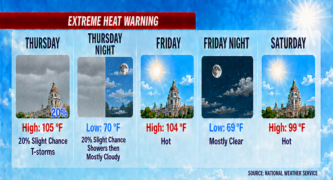
Thursday’s forecast calls for mostly cloudy skies and highs near 105 degrees. Heat index values could reach 111, with calm winds shifting to a light west-southwest breeze around 5 mph. Forecasters note a 20 percent chance of isolated showers or thunderstorms, though most rainfall is expected to evaporate before reaching the ground.
Friday will remain hot, with highs near 104 degrees. Clouds will gradually clear, and humidity will ease slightly. Winds will become south-southwest at 5 to 10 mph in the afternoon. Overnight lows will hover near 69 degrees.
Temperatures will begin to decline Saturday, dropping to 99 degrees under sunny skies. By Sunday, highs will fall to around 90 degrees, with overnight lows in the lower 60s. Monday will continue the cooling pattern, with highs near 87 degrees, close to seasonal norms.
Forecasters highlight the chance of light showers returning Tuesday and Wednesday, though precipitation is expected to be minimal. Highs will remain in the mid-to-upper 80s, with partly sunny skies.
Local officials urge Pasadena residents to take precautions during the lingering heat. Hydration, limiting outdoor activity, and checking on vulnerable populations remain critical until conditions ease. Cooling centers across the city are available for those needing relief.
Looking ahead, the National Weather Service expects temperatures to remain near normal through midweek, with only slight chances of showers from tropical moisture drifting north from Mexico.
Pasadena faces two more days of dangerous heat before a steady cooldown arrives this weekend, bringing much-needed relief to residents.
Here is the Pasadena forecast from the National Weather Service as of 3:32 a.m. Thursday:
Thursday: A 20 percent chance of showers and thunderstorms. Mostly cloudy and hot, with a high near 105. Heat index values as high as 111. Calm wind becoming west southwest around 5 mph in the afternoon.
Thursday Night: A 20 percent chance of showers before 11:00 p.m. Mostly cloudy, with a low around 70. West southwest wind around 5 mph becoming calm in the evening.
Friday: Mostly cloudy, then gradually becoming sunny and hot, with a high near 104. Heat index values as high as 110. Light and variable wind becoming south southwest 5 to 10 mph in the afternoon.
Friday Night: Mostly clear, with a low around 69. South southwest wind 5 to 10 mph becoming light in the evening.
Saturday: Sunny and hot, with a high near 99.
Saturday Night: Mostly clear, with a low around 65.
Sunday: Sunny, with a high near 90.
Sunday Night: Mostly clear, with a low around 63.
Monday: Sunny, with a high near 87.
Monday Night: Mostly clear, with a low around 61.
Tuesday: A slight chance of showers. Mostly sunny, with a high near 86.
Tuesday Night: A slight chance of showers. Partly cloudy, with a low around 63.
Wednesday: A slight chance of showers. Partly sunny, with a high near 88.
 Get our daily Pasadena newspaper in your email box. Free.
Get all the latest Pasadena news, more than 10 fresh stories daily, 7 days a week at 7 a.m.