









Pasadena residents can expect a steady warming trend this week, with daytime temperatures climbing from the mid-70s to the low 80s by the weekend as high pressure strengthens over Southern California and a developing Santa Ana weather pattern brings warmer, drier conditions, according to the National Weather Service.
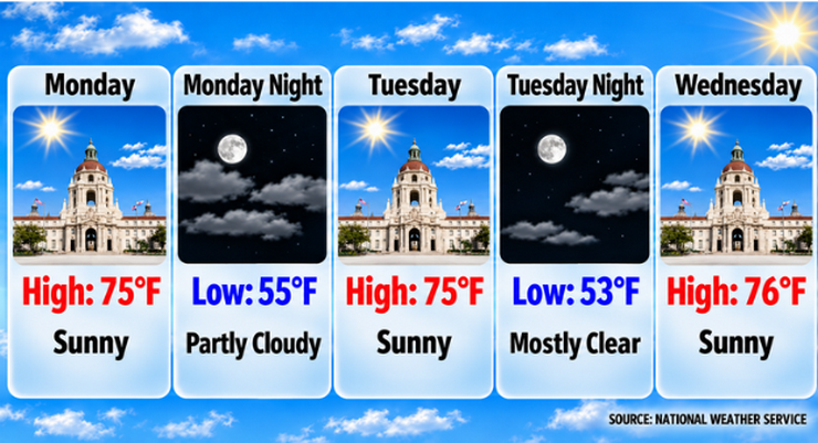
Sunny skies and a high temperature near 75 degrees are forecast for Pasadena today. National Weather Service forecasters said light north-northeast winds will shift west-southwest during the afternoon, while overnight temperatures will fall to about 55 degrees under partly cloudy skies.
The dry and seasonable weather pattern is expected to continue through midweek. Pasadena is forecast to reach 75 degrees Tuesday, 76 degrees Wednesday and 77 degrees Thursday, with clear to mostly clear skies and light winds.
According to the National Weather Service’s forecast discussion issued at 2:21 a.m. Monday, high pressure is expected to rebuild across the region following a storm system passing well to the north. Forecast models indicate increasing offshore pressure gradients from Friday through Sunday, a pattern commonly associated with Santa Ana winds.
Temperatures are expected to continue rising late in the week, reaching about 80 degrees Friday before peaking near 83 degrees Saturday and Sunday.
Forecasters said there is relatively high confidence in the warming trend, although uncertainty remains regarding the strength of the anticipated Santa Ana winds. Current model guidance suggests offshore flow will develop across Southern California, bringing lower humidity levels and additional warming.
No rain is forecast for Pasadena through the seven-day forecast period. National Weather Service forecasters expect dry conditions to persist as high pressure dominates the regional weather pattern.
Wind conditions are expected to remain generally light through Thursday, with daily shifts between weak northeasterly and onshore flows. Offshore winds could become more noticeable during the weekend as the Santa Ana pattern develops.
The weekend is expected to be the warmest period of the forecast. Highs near 83 degrees Saturday and Sunday will be nearly 8 degrees warmer than Monday’s expected high. Overnight lows will gradually rise from the mid-50s early in the week to the upper 50s by the weekend.
For Pasadena residents, the warmer temperatures and continued sunshine should provide favorable conditions for outdoor activities. However, the combination of low humidity and offshore winds could elevate fire-weather concerns in foothill areas if the Santa Ana winds strengthen.
Looking ahead, National Weather Service forecasters expect above-normal temperatures and dry weather to continue into next week, with no significant storm systems currently forecast to affect the Pasadena area.
Here is the Pasadena forecast from the National Weather Service as of 2:21 a.m. Monday:
Today: Sunny, with a high near 75. North northeast wind around 5 mph becoming west southwest in the afternoon.
Tonight: Partly cloudy, with a low around 55. Northwest wind around 5 mph becoming calm.
Tuesday: Sunny, with a high near 75. Calm wind becoming southwest around 5 mph in the morning.
Tuesday Night: Mostly clear, with a low around 53. Calm wind becoming northeast around 5 mph after midnight.
Wednesday: Sunny, with a high near 76. North northeast wind around 5 mph becoming calm in the morning.
Wednesday Night: Mostly clear, with a low around 54.
Thursday: Sunny, with a high near 77.
Thursday Night: Mostly clear, with a low around 56.
Friday: Sunny, with a high near 80.
Friday Night: Clear, with a low around 58.
Saturday: Sunny, with a high near 83.
Saturday Night: Mostly clear, with a low around 59.
Sunday: Sunny, with a high near 83.
 Get our daily Pasadena newspaper in your email box. Free.
Get all the latest Pasadena news, more than 10 fresh stories daily, 7 days a week at 7 a.m.