











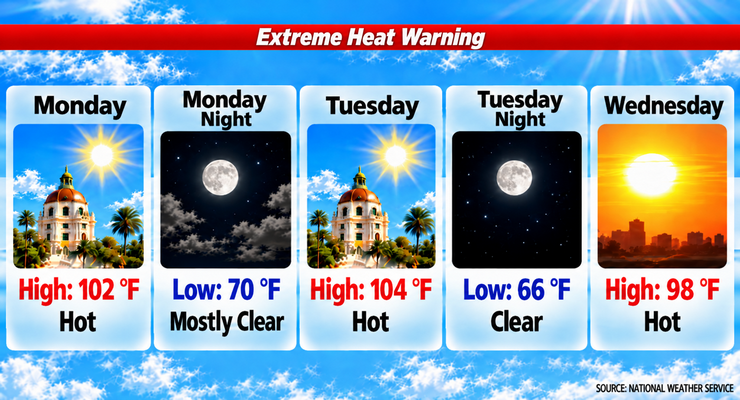
A prolonged heat wave will keep temperatures at dangerous levels across Pasadena through at least Thursday, with highs reaching as high as 104 degrees before a cooling trend arrives later in the week, according to the National Weather Service.
Forecasters said Pasadena will see sunny skies and extreme heat through midweek as a persistent high-pressure system remains over Southern California. An Extreme Heat Warning and heat advisories remain in effect across much of the region through Thursday.
Monday’s forecast calls for a high near 102 degrees under sunny skies. Light east-northeast winds around 5 mph will become west-southwest during the afternoon. Overnight temperatures will remain warm, with lows only dropping to about 70 degrees.
The hottest day of the week is expected Tuesday, when temperatures climb to around 104 degrees. Sunny conditions will continue, with light north-northeast winds becoming southwesterly in the afternoon. Tuesday night’s low is forecast near 66 degrees.
Temperatures will begin a gradual decline Wednesday, though conditions will remain hot, with a high near 98 degrees. Highs are expected to fall further to around 95 degrees on Thursday and Friday.
National Weather Service forecasters said temperatures across the region are running 15 to 22 degrees above normal. Warm overnight conditions are also contributing to the heat risk, as many locations are experiencing limited nighttime cooling.
Relief is expected to arrive during the weekend. Saturday’s high is forecast near 88 degrees under sunny skies, while Sunday’s high drops to around 80 degrees beneath mostly sunny conditions.
Forecasters also noted a slight chance of showers Sunday as moisture associated with distant Hurricane Rachel moves into Southern California. Current forecasts indicate a 20% to 30% chance of showers across Los Angeles County and areas farther south.
Winds are expected to remain generally light throughout the forecast period, with typical afternoon sea breezes providing only limited relief from the heat.
The prolonged stretch of hot weather may increase energy demand and create challenging conditions for outdoor activities across Pasadena. Forecasters advise residents to stay hydrated, avoid strenuous outdoor activities during the hottest part of the day, check on vulnerable individuals and seek air-conditioned spaces when possible.
Looking ahead, forecasters expect temperatures to continue trending cooler into next week as onshore flow strengthens and conditions return closer to seasonal norms.
Here is the Pasadena forecast from the National Weather Service as of 2:31 a.m. Monday:
Today: Sunny and hot, with a high near 102. East northeast wind around 5 mph becoming west southwest in the afternoon.
Tonight: Mostly clear, with a low around 70. West wind around 5 mph becoming northeast after midnight.
Tuesday: Sunny and hot, with a high near 104. North northeast wind around 5 mph becoming southwest in the afternoon.
Tuesday Night: Clear, with a low around 66. Southwest wind around 5 mph becoming east northeast in the evening.
Wednesday: Sunny and hot, with a high near 98. Northeast wind around 5 mph becoming calm.
Wednesday Night: Clear, with a low around 64.
Thursday: Sunny, with a high near 95.
Thursday Night: Clear, with a low around 69.
Friday: Sunny, with a high near 95.
Friday Night: Mostly clear, with a low around 67.
Saturday: Sunny, with a high near 88.
Saturday Night: Mostly clear, with a low around 62.
Sunday: Mostly sunny, with a high near 80.
 Get our daily Pasadena newspaper in your email box. Free.
Get all the latest Pasadena news, more than 10 fresh stories daily, 7 days a week at 7 a.m.