







Rain will move through Pasadena today with thunderstorms possible after 11 a.m., according to National Weather Service forecasters in Oxnard.
Forecasters put the chance of precipitation at 90% and expect between a half-inch and three-quarters of an inch of new rainfall, an unusual amount for early September in Southern California.
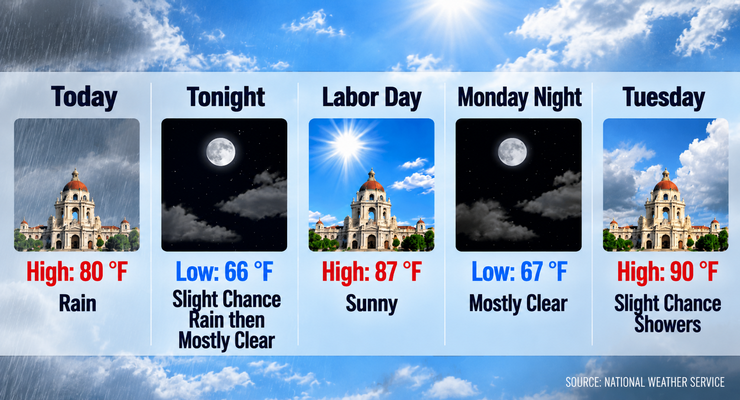
Today’s high will reach only about 80 degrees — a full 16 degrees cooler than next week’s expected peak.
Skies will stay wet and unsettled through the day. Winds start out calm this morning before turning south-southwest at around 5 mph in the afternoon. Overnight, the rain chance drops sharply to 20% before 11 p.m., and skies become partly cloudy with a low near 66. The south-southwest breeze fades back to calm during the evening.
The turnaround arrives quickly. Labor Day is forecast to be sunny with a high near 87 — a 7-degree jump from today — with light and variable winds becoming southwest at 5 to 10 mph in the afternoon. Monday night will be mostly clear with a low around 67. Tuesday brings mostly sunny skies, a high near 90 and just a 20% chance of showers, with winds shifting from north-northeast to southwest through the morning.
From there, the numbers keep climbing. Highs move from 80 today to 87 on Monday, 90 on Tuesday, 93 on Wednesday and 96 on Thursday, with Thursday described by forecasters as sunny and hot. Friday eases back to 93 and Saturday to 90. Overnight lows stay comparatively steady in the mid-60s to around 70, meaning homes will get a chance to cool off each night even as afternoons heat up.
Beyond today’s soaking, rain chances are slim. Tonight carries a 20% chance before 11 p.m., Tuesday holds a 20% chance of showers, and Wednesday keeps a 20% chance of showers before 11 a.m. After Wednesday morning, the forecast is dry through Saturday.
Winds stay light throughout the period. Expect gentle breezes of about 5 mph on most days, generally out of the southwest, with Monday afternoon topping out at 5 to 10 mph. Evenings repeatedly settle into calm conditions. No gusty or damaging winds are indicated in the forecast.
Looking to next weekend, Saturday is forecast to be sunny with a high near 90, following a Friday night low around 65. That keeps the weekend warm but a few degrees below the midweek peak, and dry — a contrast to the holiday weekend now wrapping up.
Residents in foothill neighborhoods below burn-scarred hillsides should stay alert during heavier downpours. Even a modest total of a half-inch to three-quarters of an inch can run off quickly on denuded slopes, and thunderstorms are capable of brief bursts of intense rain. Clearing gutters, storm drains and yard debris is worth the time before the heaviest activity arrives.
The forecast provided by the Weather Service does not include any active watches, warnings or advisories for the area. Even so, the standard cautions apply: avoid driving through flooded roadways, seek shelter indoors if thunder is audible, and keep an eye on official updates as conditions evolve.
Further out, the pattern points toward continued warm and dry conditions. Highs in the low 90s Friday and around 90 next Saturday suggest late-summer heat holding on rather than fading, with no meaningful rain chances in the extended outlook.
Here is the latest National Weather Service forecast for Pasadena as of Sunday,September 6 at 5:51 A.M.
Today: Rain, with thunderstorms also possible after 11am. High near 80. Calm wind becoming south southwest around 5 mph in the afternoon. The chance of precipitation is 90%. New rainfall amounts between a half and three quarters of an inch possible.
Tonight: A 20 percent chance of rain before 11pm. Partly cloudy, with a low around 66. South southwest wind around 5 mph becoming calm in the evening.
Labor Day: Sunny, with a high near 87. Light and variable wind becoming southwest 5 to 10 mph in the afternoon.
Monday Night: Mostly clear, with a low around 67. Southwest wind around 5 mph becoming calm in the evening.
Tuesday: A 20 percent chance of showers. Mostly sunny, with a high near 90. North northeast wind around 5 mph becoming southwest in the morning.
Tuesday Night: Partly cloudy, with a low around 68.
Wednesday: A 20 percent chance of showers before 11am. Mostly sunny, with a high near 93.
Wednesday Night: Mostly clear, with a low around 70.
Thursday: Sunny and hot, with a high near 96.
Thursday Night: Clear, with a low around 68.
Friday: Sunny, with a high near 93.
Friday Night: Mostly clear, with a low around 65.
Saturday: Sunny, with a high near 90.
 Get our daily Pasadena newspaper in your email box. Free.
Get all the latest Pasadena news, more than 10 fresh stories daily, 7 days a week at 7 a.m.