









Pasadena will see a dramatic shift from warm autumn weather to much cooler, wetter conditions this week as the season’s first significant storm system moves into Southern California, according to the National Weather Service.
The forecast calls for temperatures to fall from a high near 84 degrees Monday to 69 degrees by Thursday, with rain likely beginning Wednesday and continuing into Thursday. Forecasters also say there is a slight chance of thunderstorms during the storm’s peak.
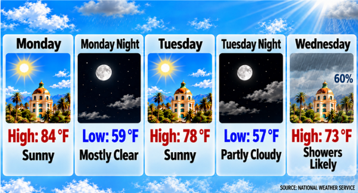
Monday is expected to be sunny with a high near 84 degrees. Light northeast winds around 5 mph will become south-southwest in the afternoon. Overnight, skies will remain mostly clear with temperatures falling to around 59 degrees.
Cooling begins Tuesday, when Pasadena is expected to reach a high near 78 degrees under sunny skies. South winds of 5 to 10 mph are forecast during the day. Tuesday night will be partly cloudy with a low around 57 degrees.
Rain chances increase significantly Wednesday as the storm system approaches. The National Weather Service forecasts showers likely after 11:00 a.m. Wednesday, with a 60% chance of precipitation and a high near 73 degrees.
Rain is expected to become more widespread Wednesday night, when the chance of precipitation rises to 90%. Forecasters say showers could be accompanied by thunderstorms as temperatures fall to around 54 degrees.
Showers are likely to continue Thursday morning before gradually diminishing. Thursday’s high is forecast near 69 degrees, making it the coolest day of the week. A slight chance of lingering showers remains Thursday evening before conditions begin to improve.
The National Weather Service said widespread rainfall associated with the system could total between three-quarters of an inch and 1 inch across much of the region, with higher amounts possible in foothill areas. Forecasters noted some uncertainty remains regarding the exact timing of the heaviest rainfall.
Winds are expected to remain relatively light through the storm, generally from the south at 5 to 10 mph. After the system moves east, breezier northwest to north winds are expected to develop Friday.
The temperature trend will be notable, with Pasadena cooling steadily from Monday’s 84-degree high to 78 degrees Tuesday, 73 degrees Wednesday and 69 degrees Thursday. The National Weather Service attributed the cooling to an upper-level low-pressure system moving down the California coast.
Dry weather is expected to return Friday, with sunny skies and a high near 72 degrees.
The weekend forecast calls for sunny conditions and a modest warmup. Temperatures are expected to reach about 77 degrees Saturday and remain near that level Sunday under mostly clear skies.
For Pasadena residents, the midweek storm could create slick roads and slower travel during Wednesday and Thursday commutes. The cooler conditions will also bring a more autumn-like feel to the city following recent warm weather.
No watches or warnings have been issued for Pasadena. However, residents are encouraged to monitor forecast updates as the storm approaches.
Looking ahead, dry conditions are expected to persist into next week as skies clear and temperatures return closer to seasonal levels.
Here is the Pasadena forecast from the National Weather Service as of 2:46 a.m. Monday:
Today: Sunny, with a high near 84. Northeast wind around 5 mph becoming south southwest in the afternoon.
Tonight: Mostly clear, with a low around 59. South southwest wind around 5 mph becoming east southeast after midnight.
Tuesday: Sunny, with a high near 78. South wind 5 to 10 mph.
Tuesday Night: Partly cloudy, with a low around 57. South southeast wind around 5 mph.
Wednesday: Showers likely, mainly after 11:00 a.m. Mostly cloudy, with a high near 73. South wind 5 to 10 mph. Chance of precipitation is 60%. New precipitation amounts between a tenth and quarter of an inch possible.
Wednesday Night: Showers and possibly a thunderstorm. Low around 54. Chance of precipitation is 90%.
Thursday: Showers likely, mainly before 11:00 a.m. Partly sunny, with a high near 69. Chance of precipitation is 60%.
Thursday Night: A slight chance of showers before 11:00 p.m. Partly cloudy, with a low around 51.
Friday: Sunny, with a high near 72.
Friday Night: Clear, with a low around 53.
Saturday: Sunny, with a high near 77.
Saturday Night: Mostly clear, with a low around 56.
Sunday: Sunny, with a high near 77.
 Get our daily Pasadena newspaper in your email box. Free.
Get all the latest Pasadena news, more than 10 fresh stories daily, 7 days a week at 7 a.m.