





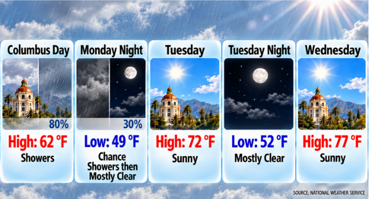
Pasadena residents can expect a dramatic shift in weather this week, beginning with cool, rainy conditions Monday before a steady warming trend pushes temperatures to near 90 degrees by Friday, according to National Weather Service forecasters.
Showers are expected throughout Columbus Day, with a high near 62 degrees and a south-southwest wind of 5 to 10 mph. The National Weather Service forecasts an 80% chance of precipitation, with rainfall amounts between one-tenth and one-quarter inch possible.
Monday’s high temperature will be well below normal for this time of year. Forecasters said the cool conditions are being driven by an upper-level low pressure system that has brought scattered showers and significantly cooler air across Southern California.
Rain chances will diminish Monday night, with a 30% chance of showers before 11:00 p.m. Skies are expected to become partly cloudy overnight as temperatures fall to around 49 degrees.
Conditions will improve rapidly Tuesday as the storm system moves east. Sunny skies are forecast with a high near 72 degrees. Light winds are expected, becoming west-southwest around 5 mph during the afternoon.
The warming trend will continue through the middle and latter part of the week. Pasadena is forecast to reach 77 degrees Wednesday, 82 degrees Thursday and 89 degrees Friday under sunny skies.
National Weather Service forecasters said weak offshore flow developing Tuesday will bring warmer and drier conditions through the remainder of the week. Temperatures are expected to peak Friday and remain unseasonably warm through the weekend.
Saturday’s forecast calls for sunny skies and a high near 88 degrees, followed by a high near 87 degrees Sunday. Overnight lows are expected to remain in the lower 60s during the weekend.
While a developing Santa Ana wind event is expected to affect parts of Southern California later this week, forecasters noted that the strongest winds are expected in mountain and valley areas. Pasadena’s forecast remains focused on the warming and drying trend.
Looking ahead, temperatures are expected to remain above normal into next week before gradually cooling. Forecasters are also monitoring the possibility of another upper-level low moving into the region during the middle of next week.
Here is the Pasadena forecast from the National Weather Service as of 3:40 a.m. Monday:
Columbus Day: Showers. High near 62. South southwest wind 5 to 10 mph. Chance of precipitation is 80%. New precipitation amounts between a tenth and quarter of an inch possible.
Monday Night: A 30 percent chance of showers before 11:00 p.m. Partly cloudy, with a low around 49. South southwest wind 5 to 10 mph becoming northwest after midnight. New precipitation amounts of less than a tenth of an inch possible.
Tuesday: Sunny, with a high near 72. Calm wind becoming west southwest around 5 mph in the afternoon.
Tuesday Night: Mostly clear, with a low around 52. West wind around 5 mph becoming calm.
Wednesday: Sunny, with a high near 77.
Wednesday Night: Mostly clear, with a low around 55.
Thursday: Sunny, with a high near 82.
Thursday Night: Clear, with a low around 62.
Friday: Sunny, with a high near 89.
Friday Night: Clear, with a low around 64.
Saturday: Sunny, with a high near 88.
Saturday Night: Clear, with a low around 62.
Sunday: Sunny, with a high near 87.
 Get our daily Pasadena newspaper in your email box. Free.
Get all the latest Pasadena news, more than 10 fresh stories daily, 7 days a week at 7 a.m.