


Another surge of rain was expected across the Southland Friday, with a high potential for flooding, after record rainfall drenched the area on Christmas Eve, according to forecasters.
“Locally heavy rain is expected … early Friday morning, especially in the mountains, with rain rates up to a 0.50-0.75 inches per hour possible,” according to the National Weather Service.
“Given the amount of water that fell [Wednesday] it won’t take much additional rain to generate significant impacts, including additional mud and rock slides through the canyons and dangerous flooding on area roads and highways.”
Forecasters said another 2 to 5 inches of rain are likely to fall in the mountains during the second wave, but other areas should receive less than 2 inches, unless isolated thunderstorms develop with heavy rains.
As of early Friday, rainfall was reported in parts of the Southland, including the Long Beach and West Los Angeles areas.
“Showers are expected to become more scattered Friday but most areas should get at least some additional rain through Friday and possible into early Saturday morning,” forecasters said.
A flood watch was in effect for wide swatches of Los Angeles County through Friday afternoon.
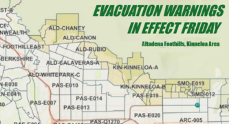
Los Angeles city and county officials issued a series of evacuation warnings and orders earlier this week in advance of the storm. The city’s evacuation warnings took effect at 11 a.m. Tuesday and were extended Thursday “until further notice” for residents near Mandeville Canyon, and the Hurst Fire and Sunset Fire burn areas.
County officials, meanwhile, issued evacuation warnings for residents near the Eaton Fire. Sheriff’s deputies reportedly went door-to-door to high-risk residences to notify them of evacuation orders at specific locations.
Sheriff Robert Luna said 124 homes in the sheriff’s unincorporated coverage area, which includes Altadena, were under evacuation orders.
Residents can check the evacuation status of their neighborhoods at protect.genasys.com.
Residents across the county can visit lacounty.gov/emergency to register for county emergency alerts, and to access links for additional local alert systems managed by other municipalities.
Gov. Gavin Newsom’s office and Los Angeles County both issued emergency proclamations due to the storm, freeing up added resources.
The first wave of a “very dangerous” atmospheric river storm dumped sometimes-torrential rain on the area Wednesday, with double-digit precipitation falling in some mountain areas, freeway flooding and fears of debris flows in recent burn areas, where residents were under evacuation warnings or orders.
Here is the forecast for Pasadena from the National Weather Service as of 3:03 a.m. Friday:
Friday: Rain and possibly a thunderstorm. Some of the storms could produce heavy rainfall. High near 61. South wind around 5 mph becoming west southwest in the afternoon. Chance of precipitation is 90%. New rainfall amounts between 1 and 2 inches possible.
Friday Night: Rain likely before 10:00 p.m. Mostly cloudy, with a low around 42. Northwest wind around 5 mph becoming calm. Chance of precipitation is 70%. New precipitation amounts of less than a tenth of an inch possible.
Saturday: Sunny, with a high near 57. Calm wind.
Saturday Night: Mostly clear, with a low around 40. Calm wind becoming north northeast around 5 mph.
Sunday: Sunny, with a high near 61.
Sunday Night: Mostly clear, with a low around 41.
Monday: Sunny, with a high near 63.
Monday Night: Mostly clear, with a low around 43.
Tuesday: Sunny, with a high near 65.
Tuesday Night: A slight chance of rain. Partly cloudy, with a low around 45.
Wednesday: A chance of rain. Partly sunny, with a high near 64.
Wednesday Night: A chance of rain. Mostly cloudy, with a low around 47.
 Get our daily Pasadena newspaper in your email box. Free.
Get all the latest Pasadena news, more than 10 fresh stories daily, 7 days a week at 7 a.m.