


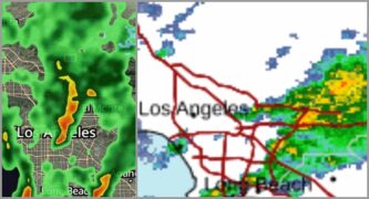


The advisory, issued at 5:10 a.m., warns that excessive rainfall is expected to cause flooding in low-lying and poorly drained areas. Doppler radar detected intense rain over southeastern Los Angeles County, with short bursts of heavy precipitation likely to overwhelm drainage systems.
Pasadena is among the cities likely to experience flooding, the NWS said.
“Turn around, don’t drown when encountering flooded roads,” the National Weather Service cautioned. “Most flood deaths occur in vehicles.”
Pasadena remains in heightened staffing status.
“The Pasadena Fire Dept. has 13 Urban Search & Rescue personnel assigned to this storm and ready to respond locally or throughout the region if needed,” Pasadena Chief Communications Officer Lisa Derderian said early Sunday. “They also have been proactively patrolling the burn scar areas. Public Works and PWP also have extra staffing to be proactive and others on-call if needed.”
Sunday’s forecast includes a 40 percent chance of showers, mainly before 4 p.m., with a high near 60 degrees and light east winds, according to the National Weather Service. New rainfall amounts between a tenth and a quarter of an inch are possible.
Sunday night brings a 30 percent chance of rain after 10 p.m., with a low of around 49 degrees and southeast winds of around 5 mph. Monday’s forecast calls for rain mainly after 10 a.m., with an 80 percent chance of precipitation and a high near 56. Rainfall amounts between a half and three-quarters of an inch are possible.
Rain is likely to continue Monday night, mainly before 10 p.m., with a 60 percent chance of precipitation and lows near 43.
“Please continue to be prepared to evacuate if you are told, allow extra time driving, if it’s trash day keeps cans a few feet from the curb so they don’t get dragged by rushing water and make sure you take off shoes and clean off pets paws before going into your residence,” Derderian said.
Residents are encouraged to monitor official updates at weather.gov/safety/flood.
 Get our daily Pasadena newspaper in your email box. Free.
Get all the latest Pasadena news, more than 10 fresh stories daily, 7 days a week at 7 a.m.


