





A deep marine layer will keep Pasadena cooler than normal through Thursday, with patchy morning light drizzle possible, before a warming trend arrives heading into the weekend, according to the National Weather Service in Oxnard.
Wednesday’s high is forecast near 80 degrees under cloudy skies that will gradually clear by afternoon. Light south-southwest winds around 5 mph will accompany the cooler conditions. Overnight lows will dip to about 59 degrees under mostly cloudy skies.
Forecasters said Thursday will bring another round of morning clouds, with highs again near 80. By Friday, offshore winds will help reduce the marine layer, leading to sunnier skies and a modest warm-up to about 83 degrees.
Temperatures will climb further over the weekend, reaching 86 degrees Saturday and 85 degrees Sunday. Despite the warming, highs will remain slightly below seasonal averages, which typically run in the upper 80s to low 90s for mid-September.
No significant rainfall is expected, though drizzle may occur during morning hours through Thursday. Winds will stay light, generally from the south and southwest, with occasional calm periods overnight.
For Pasadena residents, the persistent morning cloud cover may slow commutes and keep early hours damp, while the weekend’s sunnier conditions should favor outdoor activities. Energy demand is expected to remain moderate due to the below-normal temperatures.
No advisories or warnings are currently in effect for the Pasadena area.
Looking ahead, forecasters expect mostly sunny skies early next week, with highs ranging from the lower 80s to mid-80s. Another weak upper low may bring slight cooling and additional morning clouds by Monday before temperatures rebound Tuesday.
In summary, Pasadena will remain under the influence of a stubborn marine layer through Thursday, keeping highs near 80 with occasional drizzle. A gradual warming trend begins Friday, setting up a sunnier, warmer weekend for the city.
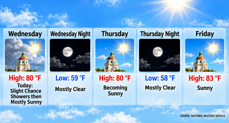
Here is the Pasadena forecast from the National Weather Service as of 2:35 a.m. Wednesday:
Wednesday: Patchy drizzle before 11:00 a.m. Cloudy through mid morning, then gradual clearing, with a high near 80. South southwest wind around 5 mph.
Wednesday Night: Mostly cloudy, with a low around 59. South southwest wind around 5 mph becoming calm after midnight.
Thursday: Partly sunny, then gradually becoming sunny, with a high near 80. Calm wind becoming south southwest around 5 mph in the afternoon.
Thursday Night: Mostly clear, with a low around 58. Southwest wind around 5 mph becoming calm in the evening.
Friday: Sunny, with a high near 83.
Friday Night: Mostly clear, with a low around 60.
Saturday: Sunny, with a high near 86.
Saturday Night: Mostly clear, with a low around 62.
Sunday: Mostly sunny, with a high near 85.
Sunday Night: Mostly clear, with a low around 60.
Monday: Sunny, with a high near 82.
Monday Night: Mostly clear, with a low around 59.
Tuesday: Sunny, with a high near 86.
 Get our daily Pasadena newspaper in your email box. Free.
Get all the latest Pasadena news, more than 10 fresh stories daily, 7 days a week at 7 a.m.


