




Pasadena will see cooler-than-normal temperatures through midweek as a deepening marine layer spreads inland, forecasters with the National Weather Service said Monday. Highs will dip into the low-to-mid 80s before warming returns by Friday.
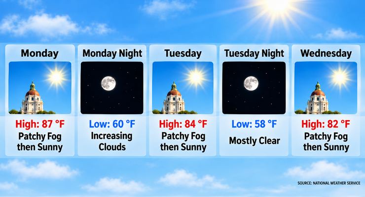
Today’s forecast calls for patchy morning fog followed by gradual clearing and a high near 87. Winds will shift from east-southeast to south-southwest in the afternoon. Overnight lows will fall near 60 under increasing cloud cover.
Tuesday and Wednesday will continue the cooling trend, with highs near 84 Tuesday and 82 Wednesday. Morning fog and low clouds are expected both days, clearing by midday. Nights will remain mild, with lows in the upper 50s.
Temperatures will run 5 to 10 degrees below normal through Wednesday, forecasters said. By Friday, highs are projected to climb back into the mid-80s to lower 90s, typical for mid-September in Pasadena.
Forecasters noted the possibility of pavement-wetting drizzle Tuesday morning as the marine layer deepens. No measurable rainfall is expected, and skies will remain mostly dry through the forecast period.
Light southeast winds will dominate early in the week, shifting to south-southwest by Wednesday. Breezes will remain gentle, generally under 10 mph, with no advisory-level gusts expected in Pasadena.
By Friday and into the weekend, sunshine will return in full force. Highs will rise to 85 Friday, 87 Saturday, and 86 Sunday, with clear skies and mild overnight lows near 60.
The cooler start to the week may ease energy demand across Pasadena neighborhoods, while the return of warmer, sunnier afternoons by Friday will favor outdoor activities and local events. Morning commuters should anticipate fog and reduced visibility through Wednesday.
No heat advisories or weather warnings are currently in effect for Pasadena. Forecasters emphasized that conditions remain stable, with no significant hazards expected.
Looking ahead to next week, forecasters expect continued seasonal warmth with highs in the 80s and mostly sunny skies. No major storm systems are projected to impact Southern California at this time.
Pasadena residents can expect foggy mornings, mild afternoons, and a steady warm-up into the weekend as conditions return to typical September weather.
Here is the Pasadena forecast from the National Weather Service as of 2:38 a.m. Monday:
Today: Patchy fog before 11:00 a.m. Otherwise, cloudy through mid morning, then gradual clearing, with a high near 87. East southeast wind 5 to 10 mph becoming south southwest in the afternoon.
Tonight: Increasing clouds, with a low around 60. Southeast wind around 5 mph.
Tuesday: Patchy fog before 11:00 a.m. Otherwise, cloudy through mid morning, then gradual clearing, with a high near 84. Southeast wind 5 to 10 mph.
Tuesday Night: Increasing clouds, with a low around 58. Southeast wind 5 to 10 mph.
Wednesday: Patchy fog before 11:00 a.m. Otherwise, mostly sunny, with a high near 82. South southwest wind around 5 mph.
Wednesday Night: Mostly clear, with a low around 58.
Thursday: Sunny, with a high near 83.
Thursday Night: Clear, with a low around 58.
Friday: Sunny, with a high near 85.
Friday Night: Clear, with a low around 60.
Saturday: Sunny, with a high near 87.
Saturday Night: Mostly clear, with a low around 60.
Sunday: Sunny, with a high near 86.
 Get our daily Pasadena newspaper in your email box. Free.
Get all the latest Pasadena news, more than 10 fresh stories daily, 7 days a week at 7 a.m.