






Cooler weather will arrive in Pasadena beginning Tuesday, with daytime highs dropping below normal and morning clouds expanding across the region, according to the National Weather Service.
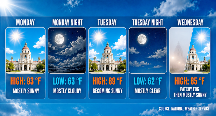
Forecasters said Monday’s high will reach near 93 under mostly sunny skies, with light south winds shifting southwest in the afternoon. Tonight will be mostly cloudy with a low around 63.
Tuesday will bring widespread morning clouds and gradual clearing. The high will reach near 89, followed by a low of 62 under increasing cloud cover. Wednesday will see patchy fog before 11:00 a.m. and partly sunny skies, with highs near 85.
Temperatures will continue to decline through Thursday, when highs are expected near 82, about 5 to 10 degrees below normal.
While monsoonal moisture lingers, the chance of thunderstorms remains low. The National Weather Service noted a 10 to 15 percent chance of afternoon storms over the San Gabriel Mountains through Wednesday. Pasadena is expected to stay dry.
Afternoon breezes from the south-southwest will continue at 5 to 10 mph. Stronger gusts are possible in foothill and desert areas, though Pasadena winds should remain below advisory levels.
Friday will be mostly sunny with highs near 84. The weekend will bring slight warming, with highs of 85 to 87 under mostly sunny skies. Overnight lows will hover near 59 to 60.
Forecasters said the cooler temperatures and persistent marine layer may slow afternoon clearing across Pasadena neighborhoods, particularly near the Arroyo and foothill areas. Residents should expect milder afternoons and occasional morning fog.
Looking ahead, gradual warming is expected early next week as onshore flow relaxes. Highs should return to the upper 80s, with continued dry conditions.
Here is the Pasadena forecast from the National Weather Service as of 3:10 a.m. Monday:
Today: Mostly sunny, with a high near 93. Light south wind becoming south southwest 5 to 10 mph in the afternoon.
Tonight: Mostly cloudy, with a low around 63. South southwest wind around 5 mph becoming calm in the evening.
Tuesday: Mostly cloudy through mid morning, then gradual clearing, with a high near 89. Light south wind becoming south southwest 5 to 10 mph in the afternoon.
Tuesday Night: Increasing clouds, with a low around 62. Southwest wind around 5 mph becoming calm in the evening.
Wednesday: Patchy fog before 11:00 a.m. Otherwise, partly sunny, with a high near 85. Calm wind becoming south southwest around 5 mph in the afternoon.
Wednesday Night: Patchy fog after 11:00 p.m. Otherwise, mostly cloudy, with a low around 60.
Thursday: Patchy fog before 11:00 a.m. Otherwise, partly sunny, with a high near 82.
Thursday Night: Partly cloudy, with a low around 59.
Friday: Mostly sunny, with a high near 84.
Friday Night: Mostly clear, with a low around 59.
Saturday: Mostly sunny, with a high near 85.
Saturday Night: Partly cloudy, with a low around 60.
Sunday: Mostly sunny, with a high near 87.
 Get our daily Pasadena newspaper in your email box. Free.
Get all the latest Pasadena news, more than 10 fresh stories daily, 7 days a week at 7 a.m.