









A dangerous stretch of triple-digit heat will grip Pasadena through midweek, forecasters said Monday, with little overnight relief expected. The National Weather Service warned that highs will peak near 105 degrees Wednesday and Thursday, keeping the San Gabriel Valley under heat advisories and warnings.
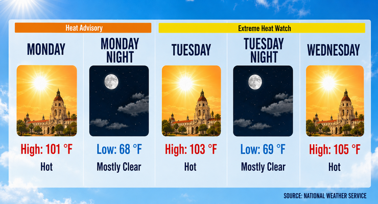
Sunny skies and calm winds will push Monday’s high to 101 degrees, with a light southwest breeze offering minimal relief. Overnight lows will remain near 68 degrees, well above seasonal norms.
Tuesday will bring hotter conditions, with highs near 103 degrees under clear skies. Winds will stay light, shifting southwest in the afternoon. Tuesday night will be mostly clear, with lows around 69 degrees. Wednesday is expected to mark the peak of the heat wave, with highs near 105 degrees and overnight lows rising to 72 degrees.
Forecasters said the week’s defining feature is persistent triple-digit heat. Highs will remain between 101 and 105 degrees through Friday before easing slightly over the weekend. Saturday will reach 99 degrees, and Sunday will stay warm at 94 degrees. Overnight lows will remain elevated, ranging from 67 to 72 degrees, preventing homes without air conditioning from cooling off.
No rain is forecast for Pasadena this week. Skies will remain mostly clear, with only occasional patchy clouds late in the week. Winds will be light and variable, generally calm in the mornings and shifting southwest at 5 mph in the afternoons.
Pasadena will see modest relief by Saturday and Sunday. Highs will dip into the upper 90s Saturday and the mid-90s Sunday, with clear skies and cooler overnight lows near 67 degrees. Despite the slight cooling, conditions will remain warmer than average.
The prolonged heat poses risks for Pasadena residents, particularly those without access to cooling. Elevated overnight lows will compound heat stress, making hydration and access to air conditioning critical. Outdoor workers, vulnerable populations, and pets are at heightened risk.
Heat advisories and warnings remain in effect across the San Gabriel Valley, including Pasadena. Officials urge residents to limit outdoor activity, stay hydrated, and check on vulnerable neighbors.
Forecasters expect a gradual cooling trend early next week as onshore flow strengthens. Highs will return closer to seasonal averages, though temperatures will remain slightly above normal.
The National Weather Service said Pasadena faces a dangerous stretch of triple-digit heat through Thursday, with little overnight relief. While modest cooling arrives by the weekend, residents should prepare for continued hot, dry conditions.
Here is the Pasadena forecast from the National Weather Service as of 2:28 a.m. Monday:
Monday: Sunny and hot, with a high near 101. Calm wind becoming southwest around 5 mph in the afternoon.
Monday Night: Mostly clear, with a low around 68. Southwest wind around 5 mph becoming calm in the evening.
Tuesday: Sunny and hot, with a high near 103. Calm wind becoming southwest around 5 mph in the afternoon.
Tuesday Night: Mostly clear, with a low around 69. Southwest wind around 5 mph becoming calm in the evening.
Wednesday: Sunny and hot, with a high near 105.
Wednesday Night: Mostly clear, with a low around 72.
Thursday: Sunny and hot, with a high near 105.
Thursday Night: Partly cloudy, with a low around 72.
Friday: Mostly sunny and hot, with a high near 101.
Friday Night: Mostly clear, with a low around 70.
Saturday: Sunny and hot, with a high near 99.
Saturday Night: Clear, with a low around 67.
Sunday: Sunny, with a high near 94.
 Get our daily Pasadena newspaper in your email box. Free.
Get all the latest Pasadena news, more than 10 fresh stories daily, 7 days a week at 7 a.m.