


The Pasadena Municipal Services Committee will review the ‘safety corridors’ methodology Tuesday at 4 p.m. in the City Council Chambers at City Hall.
The safety corridors were developed using five years of collision data from 2015 to 2019. The analysis included only injury collisions, excluding property damage incidents.
Officials weighted crashes by severity using comprehensive crash costs from the 2024 California Local Road Safety Manual. Fatal and severe injury collisions received a weight of 26 points. Evident injury crashes scored 2 points. Possible injury incidents counted as 1 point.
The methodology assigned collisions to roadway segments using a 60-foot buffer. Crashes at intersections were counted for each intersecting street.
Streets scoring above the 85th percentile on the Safety Corridor Index made the final list. Officials refined the results by comparing them to top corridors from previous safety plans.
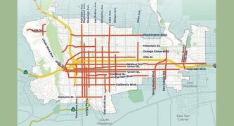
Major corridors on the list include Colorado Boulevard, Fair Oaks Avenue, and Lake Avenue. Washington Boulevard and Los Robles Avenue also made the network.
The city removed segments that recently underwent major safety improvements. Cordova Street was excluded due to a recent lane reduction project.
The safety corridors will inform project prioritization for the Pasadena Local Roadway Safety Action Plan. The network can also support efforts to reduce speed limits under state law AB 43.
Officials developed 15 priority projects based on the safety corridors analysis and community input. Eleven projects came from existing city plans. Four additional projects were generated through public engagement.
 Get our daily Pasadena newspaper in your email box. Free.
Get all the latest Pasadena news, more than 10 fresh stories daily, 7 days a week at 7 a.m.