


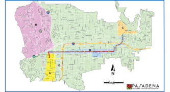


The City of Pasadena has released official Public Access Map for use by residents, businesses, and visitors planning to attend Monday’s Rose Parade and Rose Bowl Game.
New this year is an interactive public access map on the City’s website which also includes information on road closures, parking restrictions and detour routes, the City said.
The Public Access map shows areas allocated for the assembly of parade participants designated as Area A, the areas along Colorado Blvd. where most of those coming to watch the parade would be situated as Area B, and peripheral areas to the assembly area and the end of the parade as Areas C and D.
At Area A, which includes areas south of Green Street and between Grand Avenue and Pasadena Avenue, residents with appropriate passes will be allowed access, but Orange Grove Blvd. between Colorado and Columbia will be closed to all vehicular traffic between January 1st from 8 p.m. to January 2nd at 2 p.m.
Along Area B, including Colorado Blvd., Sierra Madre Blvd. and adjacent streets one block north and south, the parade route closes to through traffic at 10 p.m. on January 1. Once the parade route closes, cross traffic will be maintained at crossing points thru 6 am on January 2. Between 6 am – 2 pm on January 2, crossings will be for emergency vehicles only. Note: Colorado Street Bridge will close beginning at 8 pm on January 1 and will re-open with the rest of Colorado Blvd. on January 2.
At Area C, which covers the area north of Orange Grove Blvd. in between Altadena Drive and Sierra Madre Villa Avenue, local resident access is maintained with an appropriate pass during Post Parade event days. Sierra Madre Blvd. and Washington Blvd. will be closed to thru traffic on January 1 from 3 p.m. to January 3 at 5 a.m., however local access via Northbound Sierra Madre Blvd. will be maintained during Post Parade on January 2 and 3. Note: Be aware of posted signs (temporary and fixed) with additional parking restrictions on Altadena Drive and Orange Grove Blvd.
Area D, north of the 134 Freeway and west of the 210 Freeway, local resident access will be maintained with the appropriate pass. The Rose Bowl loop will be closed to general recreation use. Note: Be aware of posted signs (temporary and restricted) along Linda Vista Ave., South Arroyo Blvd., California Ave., Orange Grove Ave., and Walnut St.
There will be no scheduled closures on I-210 in the Pasadena area to accommodate parade-goers and fans.
In addition to the map, City officials continue to urge residents in the area and those planning to attend the Rose Parade to use their common sense and celebrate responsibly, and always to designate a driver if your New Year’s plans include drinking alcohol. Those who cannot designate a driver are advised to take a taxi, share a ride or use a shared economy service such as Uber or Lyft.
Questions can also be tweeted to @visitpasadena or via Facebook, www.facebook.com/visitpasadena/.
 Get our daily Pasadena newspaper in your email box. Free.
Get all the latest Pasadena news, more than 10 fresh stories daily, 7 days a week at 7 a.m.