


The Planning Commission will receive an information item on the Reconnecting Pasadena Master Plan (710 Stub) Project Overview.
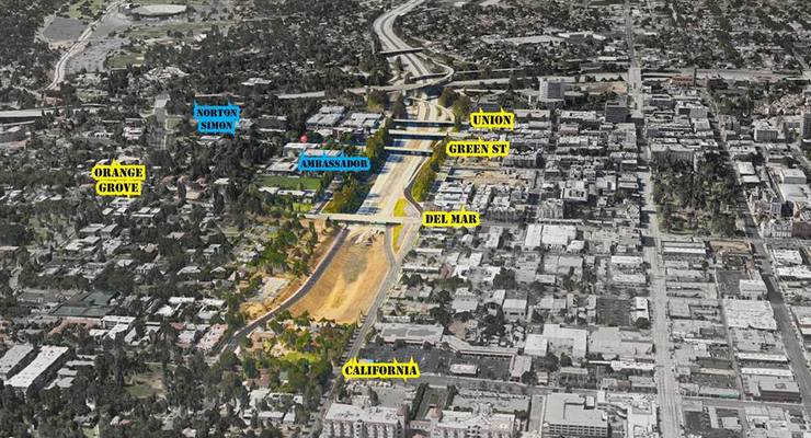
In August 2022, Caltrans transferred a 50-acre parcel known as the SR-710 Stub back to the City of Pasadena.
More than 50 years ago, Caltrans seized hundreds of homes in southwestern Pasadena, the city of South Pasadena and the Los Angeles neighborhood of El Sereno through eminent domain in what ultimately became a failed effort to connect the Long Beach 710 and Foothill 210 freeways. The state transit agency held the land for years, and over the past decade the 710 “stub,” just a few miles from Old Pasadena, served as little more than a rock quarry for Caltrans.
Caltrans also demolished dozens of African American homes in western Pasadena for the project.
The City is in the extremely early stages of an initiative that will result in revitalizing the under-utilized land while addressing community needs and mobility requirements.
In February 2023, the City Council established the 16-member Reconnecting Communities 710 Advisory Group to guide the planning process.
This group, composed of residents from each Council District and those directly impacted by previous freeway construction, is tasked with ensuring comprehensive community engagement and input on the project’s vision, land use, and restorative justice framework.
The redevelopment process will be outlined in three key documents: the Historic Report, the Master Plan, and the Specific Plan.
The Historic Report, set to be completed by early 2025, will detail the history of the SR-710 Stub and capture oral histories from residents affected by the freeway construction. This report will provide essential context for the subsequent Master Plan and Specific Plan.
In February, the City Council selected Perkins Eastman to lead the development of the Master Plan. With 40 years of experience in urban planning, Perkins Eastman will focus on several critical areas, including community engagement, restorative justice, economic analysis, mobility, land use options, and climate-resilient infrastructure.
The Master Plan will serve as a guiding document for future development, addressing vehicle, bicycle, and pedestrian circulation, land use mix, and development intensity. It will also incorporate preliminary environmental studies to inform planning decisions. Unlike typical plans, this Master Plan will not approve specific development projects but will lay the groundwork for the more detailed Specific Plan. The Specific Plan will establish development standards, design guidelines, and analyze potential impacts according to the California Environmental Quality Act (CEQA).
An upcoming informational presentation will outline the Master Plan’s phased approach and process, including the consultant team’s strategies for community engagement and alignment with the City’s General Plan goals. The presentation will also address how future development will integrate with the city’s broader design principles.
As the Master Plan progresses, updates will be presented to the Planning Commission for feedback and recommendations before proceeding to the City Council for final consideration.
 Get our daily Pasadena newspaper in your email box. Free.
Get all the latest Pasadena news, more than 10 fresh stories daily, 7 days a week at 7 a.m.